The Influence of Italian Cartography on American Mapmaking
Introduction and Purpose
Italian poet and scholar Francesco Petrarca – better known by his anglicized name, Petrarch – was a figure from the early Italian renaissance as having stating the following:
“Therefore I decided not to travel just once on a very long journey by ship or horse or on foot to those lands, but many times on a tiny map, with books and the imagination, so that in the course of an hour I could go to those shores and return as many times as I liked…not only unscathed, but unwearied too, not only with sound body, but with no wear and tear to my shoes, untouched by briars, stones, mud and dust”.

It is from this quote that I had read that I could see his desire for travel and the acquisition of knowledge while being able to remain at home. I could genuinely see that the map, at its core, is a tool that could directly the imagination of the poet and the scholar to create intellectual and artistic domains over their worldly surroundings while yet remaining at home.
As I soon approach the closing of my academic timeline as an undergraduate student at FIU, my courses have allowed me to become more immersed in my career passion of mapmaking through the usage of online programs that utilize location data – such as Esri’s ArcGIS Pro – while still being able to remain home, just like Petrarch. I could directly view the world through the lens of this mapping tool and gain greater geographical knowledge. However as I continued to produce these online projections, I began to question if and how elements of early historical cartography have carried over to the current age by asking: How has early Italian cartography served as a significant point of influence for American mapmaking and surveying? Specifically, what elements of Italian cartography are still present in the Geographic Information Systems (GIS) that we see utilized today? Are there any specific Italian cartographic techniques that have allowed for numerous different modern applications? Thus, this project will serve as a direct pathway to helping me discover the answers to these questions. Henceforth, I now present my Italia America.
Historical Background
The age of the European Renaissance would give birth to some of the most notable modern inventions such as the printing press, the pendulum, and various forms of telescopes while also serving as the period for artists to produce some of the most globally recognized works of art including Leonardo Da Vinci’s “Last Supper” and “Mona Lisa”, Sandro Botticelli’s “Birth of Venus”, Michaelangelo’s “Statue of David”, and many more works along these lines. That being said, the Renaissance would also make way for an increased emphasis on key fields of studies focusing on elements of the natural and scientific worlds with notable escalations in study for the fields of astronomy, medicine, and mathematics. However, the study of geography and cartography – in specific – would undoubtedly also join some of the aforementioned as having been furthered in knowledge acquisition by key figures in the field of mapmaking, a good number of which were Italians.
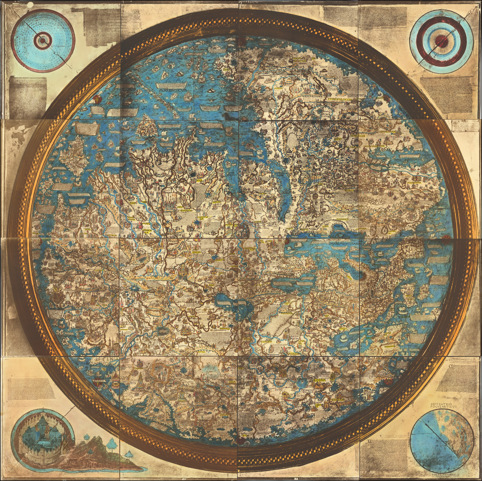
With time, the influence of Italian mapmaking during the Renaissance would embed itself within the heart of Venice as the ever-so constant study and creation of new maps yielding new cartographic elements, designs, and different purposes alike would primarily come from the work done by cartographers in the Italian city. In order to be able to recognize the effects of early Venetian cartography on the modern world and current-day American mapmaking, it is key to first draw attention to the work of Egyptian and Ancient Roman astronomer, mathematician, and geographer Claudius Ptolemy. This man would be the scholar that would become a pioneer in the study of geography and the art of cartography.
Ptolemy’s Role

Ptolemy’s recognized status as a astronomer, mathematician, and geographer all in one is recognized by his act as having authored both the “Almagest”, which focused on his work studying the mathematical and astronomical motions of the stars and planetary paths, and the “Geography”. His “Geography” proved to be such a monumental book in the field because of the fact that his book effectively served as a compilation of all knowledge regarding the world’s geography in the Roman Empire around the 2nd century – the time period in which Ptolemy was alive from 100 AD to 170 AD. However, his book and its contents would not reach the West until the beginning of the 15th century which paved the way for the Italian Renaissance to be a breaking point in the advancement of cartography. The book would prove to be revolutionary in the sense that it completely altered the modes of global and large-scale geographical illustrations that were directly accessible to Europeans, but also that this book would allow for more conceptual and practical questions to be asked regarding mapping.
When the book arrived in Florence around 1400 from Byzantium, the 8 books that were apart of his “Geography” – 7 of which mainly consisted of locational coordinates of the known world, were translated into Latin and published in Venice for the first time in 1475. What was distinctly unique about Ptolemy’s book that would undoubtedly hold great relevance in how revolutionary it held itself to be was the techniques in which the scholar utilized to compile his work. Ptolemy effectively created the concept of recording longitudes and latitudes, an element of mapmaking which is quintessential to producing a final map. This is something that is not just utilized within the United States, but also globally as it is proven effective in creating final maps. This piece alone of his work, regardless of it being 2,000 years old, is still being utilized in the modern world today as even I have to always utilize longitudes and latitudes as part of location data when making final map projects.
Furthermore, the popularity of this book is something that would inadvertently lead to the discovery of America by falling into the hands of Christopher Columbus, an Italian himself from Genoa. This piece would be one of the many books in Columbus’ collection that would assist in his navigations and explorations of the world.

The Heart of Cartography – Venezia

The city that would find itself to be at the epicenter of cartographic advancements and innovations would end up becoming Venice as the Renaissance would give birth to many key figures in the field. It would also be here where the applications of cartography would physically visualized for the world to see.
What is important to recognize as well, in relation to the impact which Italian cartography had on American mapmaking, is that as Venetian cartography grew more and furthered itself, the higher in which the level of detail imbued within these cartographic illustrations had become. The symbology relating to these maps is key to be aware of as today’s map effectively utilize legends to denote what landmarks mean what. However, one key development in the design of Venetian maps has been using mountains or hillshade to show detail to the elevation of ground at that location. In American maps in today’s day and age, this world hillshade is utilized to effectively also highlight changes in elevation on a map.
Take, for example, the work of Giacomo Gastaldi who worked primarily in Venice. Gastaldi is recognized as being among the most important figures in the Italian Renaissance when it came to cartography, in which he was able to produce a number of maps of Italy along with parts of the nation’s peninsulas. However, his map of Sicily is one that is produced with the clear showcase of landmarks along with a hillshade significant enough to let its viewers aware of the elevation there.

Maps and Literature
Particularly during the 15th century in Italy, art would be reminiscent of that of the Middle Ages. This period would come to be recognized as the “Quattrocentro” and it was during this time that cartography would find itself to be more intermingled with pieces of famous Italian literature, creating illustrations that effectively established an imaginative world through the utilization of cartography. Such an example would end up being seen with Francesco Berlinghieri’s poem titled as “Septe giornate della geographia” which attempted to create a poetic translation of Ptolemy and his work while being based off of Dante Alighieri’s “Inferno”, “Purgatorio”, and “Paradiso”. Berlinghieri interestingly enough saw himself as being Dante whereas Ptolemy was, to him, playing the role of Dante’s guide – Virgil. Girolamo Benivieni, another Italian, would come to create a cartographic illustration utilizing a projection of the globe along with some of Ptolemy’s coordinates and measurements Dante provided in the last six cantos of “Inferno” to figuratively find where hell was.

Land Surveys and Instruments
A key component of mapmaking in the modern day within the United States today is the usage of surveying techniques in order to actually be able to collect geospatial location data needed to produce a final map of whatever product is intended on being created. That said, there are various tools and instruments that directly go into this process of data collection such as a prism pole are necessary for being able to measure longitude, latitude, and height all at the same time. However, during the time of the Renaissance, mathematicians and cartographers did not have access of course to such tools and had to improvise by utilizing the natural world around them. One section from Chapter 19 of David Woodward and Uta Lindgren’s “Land Surveys, Instruments, and Practitioners in the Renaissance” details how geographical longitude had to be calculated in relation to the astronomical North Pole by observing the heights of lunar eclipses at different places simultaneously (479). These could then be processed through tables and were then input into cartographic maps and globe projections.
To me, it is completely baffling how these mathematicians and cartographers worked together to be able to compose the ideas to utilize the natural world around them in order to attain location data that can be easily attained today in comparison. It showcases a differentiation between the dynamics at play between the period of the Renaissance compared to that of today where within the US and internationally, technology developments have allowed for quicker and easier data collection. This quite easily showed me the important role in which understanding the mechanisms of the natural world plays in being able to further knowledge acquisition.
Conclusion and Takeaways
Without a doubt, the history of Italian cartography was truly birthed with the arrival of the Renaissance but the foundational knowledge that came with this time period originated more than 1200 years before Claudius Ptolemy’s work had ever arrived in the cities of Florence and Venice. Regardless of this, the age of the Renaissance would prove monumental in creating cartographic techniques and elements that would remain cemented in time in relation to their application and necessity to the overall image and quality of final map projections. These techniques and elements would appear to be quintessential in current day mapmaking as they serve the current day backbone of the cartographic process today. This is something I was only able to reflect upon with the compilation of all the knowledge I had now attained from being able to create my Italia America.
It is time now to go back and answer the original proposed question: How has early Italian cartography served as a significant point of influence for American mapmaking and surveying? Early Italian cartography, primarily that of the Renaissance, has undoubtedly served as a important stepping stone in the way cartography has been shaped today in American usage because of the concepts and techniques imbued within the process and creation of Italian maps. For example, the stress of implementing detail to geographical landmark and elevation, the ability to process data directly dealing with geographical latitudes and longitudes, the utilization of different projections based upon specific location, and the ability to create representations that can deal with location in literature texts within the maps produced by the Italian cartographers of the Renaissance are elements that have been widely adapted in the cartography we seen being done today with alterations that can fit primarily online formats. Furthermore, the process to actually create these maps has not differed greatly as the data collection process along with the step of processing the data collected is something that is still needed to be done.
What I can say is something that has dramatically differed from Italian cartography compared to current-day US mapmaking today is the difficulty of nature relating to the process itself. Whereas today, data collection and the creation of final cartographic projections can prove to be far quicker with the usage of online formats and mediums, the techniques that needed to be performed during the Italian Renaissance along with their different level of time consumption is something far more abundant than what is seen today. However, this only goes to show the innovative methods and work around tricks which the cartographers of that age had to adapt in order to come up with their final products.
References:
- All images are in the public domain
- Cosgrove, Denis. “Mapping New Worlds: Culture and Cartography in Sixteenth‐Century Venice.” Imago Mundi, vol. 44, no. 1, 1992, pp. 65–89., https://doi.org/10.1080/03085699208592741.
- “Venice & the History of Maps: Article for Seniors – Odyssey Travellers.” Venice & The History of Maps | Article for Seniors – Odyssey Travellers | Odyssey Traveller, https://www.odysseytraveller.com/articles/maps-and-venice/.
- Quist, Rachel. “Ptolemy’s Geographia.” Geography Realm, 13 Oct. 2020, https://www.geographyrealm.com/ptolemys-geographia/.
- Jones, Alexander. “Ptolemy.” Encyclopædia Britannica, Encyclopædia Britannica, Inc., https://www.britannica.com/biography/Ptolemy.
- “The ‘Lafreri School’ of Italian Mapmakers Ca. 1544-1602.” Map Forum, 8 Feb. 2022, https://mapforum.com/2022/02/08/the-lafreri-school-of-italian-mapmakers-ca-1544-1602/.
- Woodward, D and Cachey Jr. T. “Maps and Literature in Renaissance Italy“, Chapter 16. Cartography in the European Renaissance. Vol. 3, University of Chicago Press, 2007.
- Woodward, D and Lindgren U. “Land Surveys, Instruments, and Practitioners in the Renaissance“, Chapter 19. Cartography in the European Renaissance. Vol. 3, University of Chicago Press, 2007.
- Woodward, David. “The Italian Map Trade, 1480 –1650“, Chapter 31. Cartography in the European Renaissance. Vol. 3, University of Chicago Press, 2007.
- Woodward, D and Fiorani F. “Cycles of Painted Maps in the Renaissance“, Chapter 32. Cartography in the European Renaissance. Vol. 3, University of Chicago Press, 2007.
